The table below gives, for each of the listed peaks, the distance, azimuth and elevation angle of the other peaks. Be warned that any given peak might not be observable if it is blocked by an intervening peak or ridge.
See How To Calculate Distances, Azimuths and Elevation Angles Of Peaks for the formulae used, as well as definitions of these parameters.
I obtained the coordinates for these peaks from the USGS Geographic Names Information System. Hence the names in the table are the official names, so be aware that Mt. Baldy is actually called Mount San Antonio by the government, even if no one in Southern California uses that name!
To use this table, look down the first column to find the peak on which you are standing. Each peak has three entries in that column: the official peak name, the county in which the peak is located, and the name of the 7.5' USGS Topographic map on which the peak is located.
The rows corresponding to that entry give the observed distance (in miles), azimuth (in degrees), and elevation angle (in degrees) for the peak named at the top of each column.
The azimuthal angle is the direction in which you need to look in order to see the observed peak. Angles of 0° = north, 90° = east, 180° = south and 270° = west. The elevation angle is the distance above (positive) or below (negative) the horizon at which you'll find the observed peak.
See Highlighted Instructions For The Use Of This Table for further instruction.
The table is not complete, with only 19 of the most prominent peaks of the Hundred Peaks in Southern California listed. The columns are roughly ordered by the order of the ANF peaks from west to east, followed by approximate azimuthal order for the non-ANF peaks as seen from the ANF.
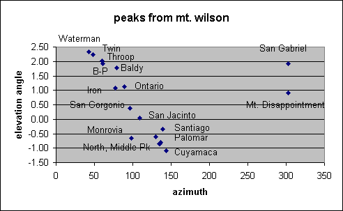
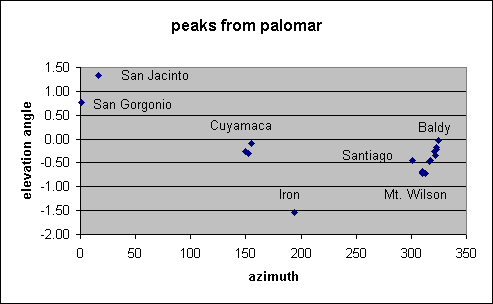
One way to use these parameters is to plot the elevation angle vs. azimuth for a given location. Many spreadsheet programs such as Excel97 can open an html file, making it simple to plot one row vs. another to accomplish this. See View From Mt. Wilson and View From Palomar Mountain for examples.
| San Gabriel Peak | Mount Disappointment | Mount Wilson | Monrovia Peak | Twin Peaks | Waterman Mountain | Throop Peak | Mount Baden-Powell | Iron Mountain | Mount San Antonio | Ontario Peak | San Gorgonio Mountain | San Jacinto Peak | Palomar Mountain | North Peak | Middle Peak | Cuyamaca Peak | Iron Mountain | Santiago Peak | ||||||||||||||||||||
|---|---|---|---|---|---|---|---|---|---|---|---|---|---|---|---|---|---|---|---|---|---|---|---|---|---|---|---|---|---|---|---|---|---|---|---|---|---|---|
| San Gabriel Peak | 0.4 | 2.5 | 7.7 | 10.6 | 11.2 | 18.6 | 20.6 | 22.2 | 26.0 | 27.1 | 73.2 | 86.4 | 94.5 | 121.9 | 122.6 | 124.0 | 109.7 | 49.0 | ||||||||||||||||||||
| Los Angeles | 302.3 | 122.3 | 105.8 | 61.6 | 55.2 | 66.4 | 67.2 | 81.9 | 82.9 | 92.1 | 97.4 | 109.6 | 129.6 | 134.1 | 134.9 | 135.8 | 142.9 | 138.6 | ||||||||||||||||||||
| Mount Wilson | -5.1 | -2.0 | -1.1 | 1.6 | 1.7 | 1.6 | 1.6 | 0.8 | 1.5 | 0.8 | 0.3 | 0.0 | -0.6 | -0.8 | -0.8 | -0.9 | -1.1 | -0.4 | ||||||||||||||||||||
| Mount Disappointment | 0.4 | 2.9 | 8.1 | 10.9 | 11.4 | 18.8 | 20.9 | 22.5 | 26.3 | 27.5 | 73.6 | 86.9 | 95.0 | 122.3 | 123.0 | 124.4 | 110.1 | 49.4 | ||||||||||||||||||||
| Los Angeles | 122.3 | 122.3 | 106.6 | 63.5 | 57.2 | 67.5 | 68.2 | 82.6 | 83.5 | 92.6 | 97.5 | 109.7 | 129.6 | 134.0 | 134.9 | 135.8 | 142.8 | 138.4 | ||||||||||||||||||||
| Mount Wilson | 5.1 | -0.9 | -0.8 | 1.7 | 1.9 | 1.7 | 1.7 | 0.8 | 1.5 | 0.9 | 0.3 | 0.0 | -0.6 | -0.8 | -0.8 | -0.8 | -1.0 | -0.4 | ||||||||||||||||||||
| Mount Wilson | 2.5 | 2.9 | 5.3 | 9.7 | 10.5 | 17.3 | 19.3 | 20.4 | 24.1 | 25.0 | 70.9 | 84.0 | 92.0 | 119.4 | 120.1 | 121.6 | 107.4 | 46.5 | ||||||||||||||||||||
| Los Angeles | 302.3 | 302.3 | 98.1 | 48.5 | 42.5 | 59.6 | 61.1 | 77.3 | 79.1 | 89.3 | 96.5 | 109.3 | 129.9 | 134.3 | 135.2 | 136.1 | 143.4 | 139.4 | ||||||||||||||||||||
| Mount Wilson | 1.9 | 0.9 | -0.6 | 2.2 | 2.3 | 2.0 | 1.9 | 1.1 | 1.8 | 1.1 | 0.4 | 0.1 | -0.5 | -0.7 | -0.8 | -0.7 | -1.0 | -0.3 | ||||||||||||||||||||
| Monrovia Peak | 7.7 | 8.1 | 5.3 | 7.4 | 8.7 | 13.5 | 15.4 | 15.5 | 19.1 | 19.7 | 65.6 | 78.8 | 87.6 | 115.2 | 115.9 | 117.4 | 103.7 | 42.7 | ||||||||||||||||||||
| Los Angeles | 285.8 | 286.7 | 278.1 | 15.5 | 12.3 | 45.5 | 49.2 | 70.4 | 74.0 | 86.9 | 96.5 | 110.1 | 131.8 | 135.9 | 136.9 | 137.7 | 145.5 | 144.2 | ||||||||||||||||||||
| Azusa | 1.0 | 0.7 | 0.6 | 3.4 | 3.2 | 2.9 | 2.7 | 1.7 | 2.5 | 1.7 | 0.6 | 0.2 | -0.5 | -0.7 | -0.7 | -0.7 | -1.0 | -0.2 | ||||||||||||||||||||
| Twin Peaks | 10.6 | 10.9 | 9.7 | 7.4 | 1.3 | 8.0 | 10.1 | 12.8 | 16.5 | 18.7 | 64.9 | 79.7 | 91.1 | 119.1 | 120.0 | 121.5 | 108.6 | 47.7 | ||||||||||||||||||||
| Los Angeles | 241.7 | 243.6 | 228.5 | 195.5 | 354.6 | 73.0 | 73.3 | 98.7 | 96.6 | 109.0 | 103.0 | 115.4 | 136.0 | 139.0 | 139.9 | 140.7 | 148.5 | 151.2 | ||||||||||||||||||||
| Waterman Mountain | -1.7 | -1.9 | -2.4 | -3.5 | 2.2 | 1.8 | 1.7 | 0.1 | 1.4 | 0.4 | 0.2 | -0.1 | -0.8 | -0.9 | -0.9 | -0.9 | -1.2 | -0.8 | ||||||||||||||||||||
| Waterman Mountain | 11.2 | 11.4 | 10.5 | 8.7 | 1.3 | 7.9 | 9.9 | 13.2 | 16.8 | 19.3 | 65.3 | 80.4 | 92.1 | 120.2 | 121.1 | 122.7 | 109.8 | 48.9 | ||||||||||||||||||||
| Los Angeles | 235.3 | 237.3 | 222.6 | 192.3 | 174.6 | 82.7 | 80.9 | 104.4 | 101.1 | 112.7 | 104.1 | 116.3 | 136.5 | 139.4 | 140.3 | 141.1 | 148.8 | 151.8 | ||||||||||||||||||||
| Waterman Mountain | -1.9 | -2.0 | -2.5 | -3.3 | -2.2 | 1.5 | 1.4 | -0.1 | 1.2 | 0.2 | 0.2 | -0.1 | -0.8 | -1.0 | -1.0 | -0.9 | -1.2 | -0.8 | ||||||||||||||||||||
| Throop Peak | 18.6 | 18.8 | 17.3 | 13.5 | 8.0 | 7.9 | 2.1 | 6.5 | 9.7 | 13.1 | 58.0 | 74.0 | 87.7 | 116.1 | 117.1 | 118.7 | 106.9 | 46.7 | ||||||||||||||||||||
| Los Angeles | 246.6 | 247.7 | 239.7 | 225.6 | 253.1 | 262.8 | 74.4 | 131.0 | 116.0 | 130.2 | 107.0 | 119.7 | 140.7 | 142.7 | 143.6 | 144.4 | 152.8 | 161.0 | ||||||||||||||||||||
| Crystal Lake | -1.9 | -2.0 | -2.3 | -3.1 | -1.9 | -1.6 | 1.4 | -1.9 | 1.0 | -0.5 | 0.1 | -0.2 | -0.9 | -1.0 | -1.1 | -1.0 | -1.3 | -1.1 | ||||||||||||||||||||
| Mount Baden-Powell | 20.6 | 20.9 | 19.3 | 15.4 | 10.1 | 9.9 | 2.1 | 5.7 | 8.3 | 12.1 | 56.3 | 72.5 | 86.9 | 115.3 | 116.3 | 118.0 | 106.5 | 46.6 | ||||||||||||||||||||
| Los Angeles | 247.4 | 248.4 | 241.3 | 229.3 | 253.4 | 261.0 | 254.4 | 148.7 | 125.6 | 138.4 | 108.2 | 120.9 | 142.0 | 143.7 | 144.6 | 145.4 | 153.9 | 163.5 | ||||||||||||||||||||
| Crystal Lake | -1.8 | -1.9 | -2.2 | -2.9 | -1.8 | -1.6 | -1.4 | -2.7 | 0.8 | -0.7 | 0.0 | -0.3 | -1.0 | -1.1 | -1.1 | -1.0 | -1.4 | -1.2 | ||||||||||||||||||||
| Iron Mountain | 22.2 | 22.5 | 20.4 | 15.5 | 12.8 | 13.2 | 6.5 | 5.7 | 3.8 | 6.6 | 52.1 | 67.6 | 81.3 | 109.7 | 110.7 | 112.4 | 100.9 | 41.2 | ||||||||||||||||||||
| Los Angeles | 262.1 | 262.8 | 257.5 | 250.5 | 278.9 | 284.6 | 311.0 | 328.8 | 89.4 | 129.5 | 104.2 | 118.7 | 141.5 | 143.5 | 144.4 | 145.2 | 154.2 | 165.6 | ||||||||||||||||||||
| Mount San Antonio | -1.0 | -1.1 | -1.4 | -1.9 | -0.3 | -0.1 | 1.8 | 2.6 | 5.9 | 1.1 | 0.4 | 0.0 | -0.8 | -0.9 | -0.9 | -0.9 | -1.2 | -0.9 | ||||||||||||||||||||
| Mount San Antonio | 26.0 | 26.3 | 24.1 | 19.1 | 16.5 | 16.8 | 9.7 | 8.3 | 3.8 | 4.4 | 48.5 | 64.3 | 79.0 | 107.5 | 108.6 | 110.3 | 99.3 | 40.4 | ||||||||||||||||||||
| San Bernardino | 263.2 | 263.8 | 259.4 | 254.2 | 276.8 | 281.2 | 296.1 | 305.7 | 269.4 | 162.9 | 105.3 | 120.3 | 143.7 | 145.2 | 146.0 | 146.9 | 156.2 | 170.8 | ||||||||||||||||||||
| Mount San Antonio | -1.8 | -1.9 | -2.1 | -2.8 | -1.6 | -1.4 | -1.1 | -0.9 | -5.9 | -3.4 | 0.0 | -0.3 | -1.0 | -1.1 | -1.1 | -1.1 | -1.4 | -1.4 | ||||||||||||||||||||
| Ontario Peak | 27.1 | 27.5 | 25.0 | 19.7 | 18.7 | 19.3 | 13.1 | 12.1 | 6.6 | 4.4 | 46.3 | 61.1 | 74.9 | 103.3 | 104.3 | 106.1 | 94.9 | 36.1 | ||||||||||||||||||||
| San Bernardino | 272.4 | 272.9 | 269.5 | 267.1 | 289.2 | 292.8 | 310.3 | 318.4 | 309.5 | 342.9 | 100.7 | 117.6 | 142.6 | 144.4 | 145.4 | 146.2 | 155.9 | 171.8 | ||||||||||||||||||||
| Cucamonga Peak | -1.2 | -1.3 | -1.5 | -1.9 | -0.7 | -0.5 | 0.3 | 0.6 | -1.2 | 3.3 | 0.4 | 0.0 | -0.9 | -0.9 | -1.0 | -0.9 | -1.3 | -1.1 | ||||||||||||||||||||
| San Gorgonio Mountain | 73.2 | 73.6 | 70.9 | 65.6 | 64.9 | 65.3 | 58.0 | 56.3 | 52.1 | 48.5 | 46.3 | 21.5 | 50.9 | 76.8 | 78.5 | 80.7 | 78.3 | 48.6 | ||||||||||||||||||||
| San Bernardino | 278.1 | 278.2 | 277.2 | 277.1 | 283.6 | 284.7 | 287.6 | 288.7 | 284.6 | 285.8 | 281.2 | 156.5 | 180.5 | 169.5 | 170.3 | 170.8 | 185.4 | 236.5 | ||||||||||||||||||||
| San Gorgonio Mountain | -1.3 | -1.3 | -1.3 | -1.4 | -1.0 | -1.0 | -0.8 | -0.8 | -1.1 | -0.6 | -1.0 | -0.5 | -1.5 | -1.3 | -1.3 | -1.2 | -1.7 | -1.6 | ||||||||||||||||||||
| San Jacinto Peak | 86.4 | 86.9 | 84.0 | 78.8 | 79.7 | 80.4 | 74.0 | 72.5 | 67.6 | 64.3 | 61.1 | 21.5 | 32.4 | 56.0 | 57.8 | 60.1 | 60.4 | 49.6 | ||||||||||||||||||||
| Riverside | 290.4 | 290.5 | 290.1 | 290.8 | 296.1 | 297.0 | 300.3 | 301.5 | 299.2 | 300.9 | 298.1 | 336.6 | 196.2 | 174.5 | 175.4 | 176.0 | 195.4 | 261.9 | ||||||||||||||||||||
| San Jacinto Peak | -1.1 | -1.2 | -1.2 | -1.3 | -0.9 | -0.9 | -0.7 | -0.7 | -0.9 | -0.5 | -0.8 | 0.2 | -1.8 | -1.3 | -1.3 | -1.2 | -1.8 | -1.4 | ||||||||||||||||||||
| Palomar Mountain | 94.5 | 95.0 | 92.0 | 87.6 | 91.1 | 92.1 | 87.7 | 86.9 | 81.3 | 79.0 | 74.9 | 50.9 | 32.4 | 28.6 | 29.8 | 31.7 | 28.0 | 46.8 | ||||||||||||||||||||
| San Diego | 310.3 | 310.3 | 310.5 | 312.4 | 316.6 | 317.1 | 321.2 | 322.5 | 322.0 | 324.2 | 323.1 | 0.5 | 16.1 | 149.5 | 152.6 | 155.2 | 194.3 | 301.0 | ||||||||||||||||||||
| Palomar Observatory | -0.6 | -0.6 | -0.6 | -0.7 | -0.4 | -0.4 | -0.2 | -0.2 | -0.3 | 0.0 | -0.1 | 0.8 | 1.4 | -0.2 | -0.3 | -0.1 | -1.5 | -0.4 | ||||||||||||||||||||
| North Peak | 121.9 | 122.3 | 119.4 | 115.2 | 119.1 | 120.2 | 116.1 | 115.3 | 109.7 | 107.5 | 103.3 | 76.8 | 56.0 | 28.6 | 2.0 | 4.3 | 21.5 | 73.2 | ||||||||||||||||||||
| San Diego | 314.9 | 314.9 | 315.1 | 316.7 | 319.8 | 320.2 | 323.4 | 324.4 | 324.1 | 325.7 | 325.0 | 349.6 | 354.5 | 329.7 | 203.8 | 195.8 | 263.5 | 311.9 | ||||||||||||||||||||
| Julian | -0.8 | -0.8 | -0.8 | -0.8 | -0.6 | -0.6 | -0.5 | -0.4 | -0.5 | -0.3 | -0.4 | 0.3 | 0.6 | -0.1 | -0.6 | 1.3 | -1.8 | -0.5 | ||||||||||||||||||||
| Middle Peak | 122.6 | 123.0 | 120.1 | 115.9 | 120.0 | 121.1 | 117.1 | 116.3 | 110.7 | 108.6 | 104.3 | 78.5 | 57.8 | 29.8 | 2.0 | 2.4 | 20.6 | 73.8 | ||||||||||||||||||||
| San Diego | 315.8 | 315.7 | 316.0 | 317.6 | 320.6 | 321.0 | 324.3 | 325.2 | 325.0 | 326.6 | 325.9 | 350.4 | 355.5 | 332.8 | 23.8 | 189.1 | 268.3 | 313.4 | ||||||||||||||||||||
| Cuyamaca Peak | -0.8 | -0.8 | -0.8 | -0.8 | -0.6 | -0.6 | -0.5 | -0.4 | -0.5 | -0.3 | -0.4 | 0.3 | 0.6 | -0.1 | 0.6 | 2.9 | -1.8 | -0.5 | ||||||||||||||||||||
| Cuyamaca Peak | 124.0 | 124.4 | 121.6 | 117.4 | 121.5 | 122.7 | 118.7 | 118.0 | 112.4 | 110.3 | 106.1 | 80.7 | 60.1 | 31.7 | 4.3 | 2.4 | 20.3 | 75.1 | ||||||||||||||||||||
| San Diego | 316.6 | 316.6 | 316.9 | 318.5 | 321.5 | 321.8 | 325.1 | 326.0 | 325.8 | 327.4 | 326.8 | 350.9 | 356.0 | 335.3 | 15.8 | 9.1 | 274.8 | 314.8 | ||||||||||||||||||||
| Cuyamaca Peak | -0.8 | -0.9 | -0.9 | -0.9 | -0.7 | -0.7 | -0.5 | -0.5 | -0.6 | -0.4 | -0.5 | 0.1 | 0.4 | -0.3 | -1.3 | -2.9 | -2.2 | -0.6 | ||||||||||||||||||||
| Iron Mountain | 109.7 | 110.1 | 107.4 | 103.7 | 108.6 | 109.8 | 106.9 | 106.5 | 100.9 | 99.3 | 94.9 | 78.3 | 60.4 | 28.0 | 21.5 | 20.6 | 20.3 | 61.0 | ||||||||||||||||||||
| San Diego | 323.5 | 323.4 | 324.0 | 326.1 | 329.1 | 329.4 | 333.2 | 334.3 | 334.6 | 336.6 | 336.3 | 5.3 | 15.2 | 14.2 | 83.3 | 88.1 | 94.6 | 327.0 | ||||||||||||||||||||
| San Vicente Reservoir | -0.4 | -0.4 | -0.4 | -0.4 | -0.2 | -0.2 | 0.0 | 0.0 | -0.1 | 0.2 | 0.1 | 0.7 | 1.1 | 1.2 | 1.5 | 1.5 | 1.9 | 0.1 | ||||||||||||||||||||
| Santiago Peak | 49.0 | 49.4 | 46.5 | 42.7 | 47.7 | 48.9 | 46.7 | 46.6 | 41.2 | 40.4 | 36.1 | 48.6 | 49.6 | 46.8 | 73.2 | 73.8 | 75.1 | 61.0 | ||||||||||||||||||||
| Orange | 318.9 | 318.7 | 319.7 | 324.5 | 331.4 | 332.1 | 341.1 | 343.7 | 345.7 | 350.9 | 351.8 | 56.1 | 81.4 | 120.6 | 131.4 | 132.8 | 134.3 | 146.7 | ||||||||||||||||||||
| Santiago Peak | -0.2 | -0.3 | -0.3 | -0.3 | 0.2 | 0.2 | 0.5 | 0.6 | 0.3 | 0.9 | 0.7 | 1.0 | 0.8 | -0.2 | -0.4 | -0.4 | -0.4 | -0.9 | ||||||||||||||||||||
Go To:
Copyright © 1998-1999 by Tom Chester.
Permission is freely granted to reproduce any or all of this page as long as credit is given to me at this source:
http://la.znet.com/~schester/angeles_mtns/tables/peak_view_params.html
Comments and feedback: Tom Chester
Last update: 15 April 1999.