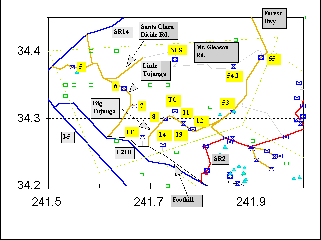
Hikes in the Angeles National Forest, Tujunga Region

Explanation of map
Map Without Labels
Trailhead Abbreviations On Map
| Abbreviation | Full Name | Numbered Hikes Beginning At That Trailhead
|
|---|
| EC | Ebey Canyon | 7.5
|
| NFS | North Fork Saddle | 7.5
|
| TC | Trail Canyon | 9, 10, 10.22
|
If a link for the number of the hike is present, the link will get either:
- a complete guide to the trail, including a map of the trailhead, trail condition, a plot of altitude versus distance, and a description of the views from the trail, or
- current trail conditions as reported to me.
If a link for the name of the hike is present, the link will get all the web information available for that trail, including my trip logs.
Explanation of column headings.
| No. | RT
miles | Elev.
gain | Season | Name
|
|---|
| 5 | 8 | 1800 | oct-june | Placerita Canyon County Park to Walker Ranch Campground, Los Pinetos Spring, Los Pinetos Ridge, Firebreak Ridge, Manzanita Mountain
|
| 6 | 7 | 800 | oct-may | Dillon Divide to Pacoima Canyon, Dutch Louie Flat, Dagger Flat
|
| 7 | 8 | 2000 | nov-may | Gold Creek to Oak Spring, Fascination Spring
|
| 7.5 | 21
(1 way) | +8940
-6051 | nov-may | Sunland to North Fork Saddle via Ebey Canyon, Yerba Buena Ridge Road, Yerba Buena Trail
|
| 8 | 6 | 1600 | nov-may | Big Tujunga to Gold Canyon, Yerba Buena Ridge
|
| 9 | 8 | 2000 | nov-jun | Big Tujunga to Tom Lucas Trail Camp, Big Cienaga
|
| 10 | 11
(1 way) | 4200 | may-oct | Big Tujunga to Tom Lucas Trail Camp, Indian Ben Saddle, Upper Pacoima Canyon, Deer Spring, Messenger Flats Campground
|
| 10.22 | 22 | 4200 | may-oct | Big Tujunga to Tom Lucas Trail Camp, Indian Ben Saddle, Upper Pacoima Canyon, Deer Spring, Messenger Flats Campground
|
| 11 | 8 | 3200 | nov-may | Big Tujunga to Mt. Lukens via Stone Canyon Trail
|
| 12 | 16 | 3400 | nov-may | Big Tujunga to Condor Peak via Fox Divide
|
| 13 | 5 | 900 | nov-may | Big Tujunga to Grizzly Flat and Vasquez Creek
|
| 14 | 8 | 2800 | nov-may | Tujunga to Mt. Lukens via Haines Canyon Trail
|
| 53 | 4 | +400
-400 | all | Angeles Forest Highway to Big Tujunga Narrows
|
| 54.1 | 5 | 1000 | may-oct | Mt. Gleason Road to Mt. Gleason, Gleason Mines
|
| 55 | 8 | 2200 | may-oct | Mill Creek Summit to Pacifico Mountain
|
Mileages, altitude gain/loss, season and name for whole-integer hike numbers taken from Trails of the Angeles by John W. Robinson, Sixth Edition, January 1990, published by Wilderness Press. All entries for hike numbers that have extended hike numbers with decimals or dashes in the name supplied by T. Chester. A hike with number "x.22" is a round-trip hike made out of doubling the one-way hike #x, and a hike with "x.33" is the same hike as "x.22" but starting at the opposite trailhead. If you are confused, don't worry about it! Just read the hike parameters in the table.
Go To:
Copyright © 1997-1999 by Tom Chester.
Permission is freely granted to reproduce any or all of this page as long as credit is given to me at this source:
http://la.znet.com/~schester/angeles_mtns/regions/tujunga.html
Comments and feedback: Tom Chester
Last update: 10 December 1999.

